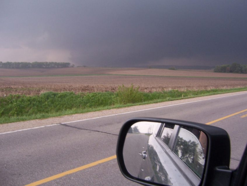
A typical Memorial Day weekend was in the works across the state. It was a Sunday, many people were running around, graduation parties were taking shape, people were outside enjoying the warm weather that encompassed the state that day. Meanwhile the atmosphere was about to unleash a monster that would be the first catastrophic tornado to hit the state in nearly 32 years. The Storm Prediction Center had been concerned about the possibility of severe weather for days.
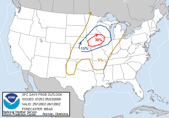
In their statement they mentioned the following
THE COMBINATION OF THE MODERATE TO STRONG INSTABILITY AND MODERATELY STRONG DEEP LAYER SHEAR INDICATE THE POTENTIAL FOR SUPERCELLS AND/OR LARGER-SCALE BOWING STRUCTURES CAPABLE OF LARGE HAIL…DAMAGING WINDS AND A FEW TORNADOES
By the morning of the event, the Storm Prediction Center had the state in a slight risk of severe weather with an enhanced risk for tornadoes.
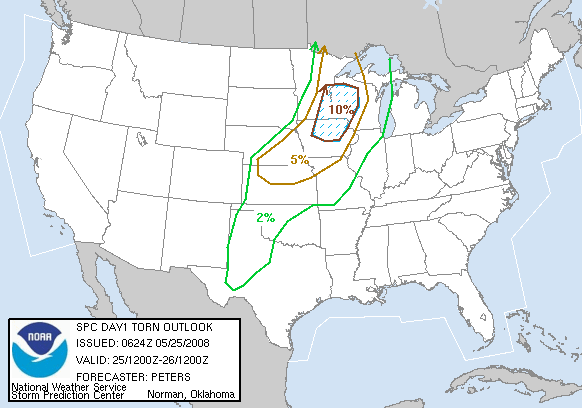
Here was their wording in that first outlook issued at 6z (1am Sunday Morning)
View Text
SWLY LOW LEVEL WINDS ARE EXPECTED TO PERSIST TODAY FROM THE CENTRAL
PLAINS INTO THE UPPER MS VALLEY/WRN GREAT LAKES REGION AS NRN PLAINS
UPPER TROUGH SHIFTS EWD. THIS WILL ALLOW MOISTURE TO CONTINUE TO
SURGE NEWD AS WARM FRONT LIFTS TOWARD THE UPPER GREAT LAKES.
SURFACE DEWPOINTS IN THE LOWER 60S SHOULD REACH PARTS OF NERN MN/WRN
UPPER MI…WITH UPPER 60S-AROUND 70 LIKELY INTO ERN IA/SWRN WI.
SURFACE HEATING IS EXPECTED TO COMMENCE LATER THIS MORNING IN THE
WAKE OF EARLY MORNING CONVECTION…AND AHEAD OF PRE-FRONTAL TROUGH.
THIS COMBINED WITH THE MOISTURE AND STEEP MID LEVEL LAPSE RATES WILL
SUPPORT A MODERATE-VERY UNSTABLE AIR MASS /MUCAPE RANGING FROM
2000-3500 J/KG/ FROM SERN MN/SWRN WI TO SERN NEB AND ERN KS.
RIGHT ENTRANCE REGION OF AN UPPER LEVEL JET WILL BE OVER THE UPPER
GREAT LAKES. THIS COMBINED WITH ASCENT ATTENDANT TO HEIGHT FALLS AS
NRN PLAINS LOW SHIFTS EWD AND SEVERAL MID LEVEL IMPULSES TRACK NEWD
WITHIN STRONG SWLY FLOW ALOFT WILL AID IN THE DEVELOPMENT OF TSTMS
THIS AFTERNOON FROM THE NRN MN SURFACE LOW SWWD ALONG THE TRAILING
PRE-FRONTAL TROUGH TO THE CENTRAL PLAINS. EFFECTIVE BULK SHEAR
AROUND 50 KT ACROSS THIS ENTIRE REGION SUGGESTS THREAT FOR TORNADIC
SUPERCELLS…SOME STRONG INTO THE UPPER MS VALLEY. THE STRONG
INSTABILITY AND STEEP LAPSE RATES WILL ENHANCE THE POTENTIAL FOR
HAIL…SOME VERY LARGE…AND DAMAGING WINDS.
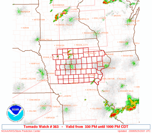
The storms waited until mid-afternoon to fire. The Storm Prediction Center issued a PDS Tornado Watch at 3:30pm that afternoon. Here was the wording on that
View Text
URGENT – IMMEDIATE BROADCAST REQUESTED
TORNADO WATCH NUMBER 363
NWS STORM PREDICTION CENTER NORMAN OK
330 PM CDT SUN MAY 25 2008

THE NWS STORM PREDICTION CENTER HAS ISSUED A
TORNADO WATCH FOR PORTIONS OF

A LARGE PART OF IOWA

EFFECTIVE THIS SUNDAY AFTERNOON AND EVENING FROM 330 PM UNTIL
1000 PM CDT.

…THIS IS A PARTICULARLY DANGEROUS SITUATION…

DESTRUCTIVE TORNADOES…LARGE HAIL TO 3 INCHES IN DIAMETER…
THUNDERSTORM WIND GUSTS TO 80 MPH…AND DANGEROUS LIGHTNING ARE
POSSIBLE IN THESE AREAS.

THE TORNADO WATCH AREA IS APPROXIMATELY ALONG AND 75 STATUTE
MILES NORTH AND SOUTH OF A LINE FROM 60 MILES SOUTHWEST OF FORT
DODGE IOWA TO 50 MILES EAST SOUTHEAST OF CEDAR RAPIDS IOWA. FOR
A COMPLETE DEPICTION OF THE WATCH SEE THE ASSOCIATED WATCH
OUTLINE UPDATE (WOUS64 KWNS WOU3).

REMEMBER…A TORNADO WATCH MEANS CONDITIONS ARE FAVORABLE FOR
TORNADOES AND SEVERE THUNDERSTORMS IN AND CLOSE TO THE WATCH
AREA. PERSONS IN THESE AREAS SHOULD BE ON THE LOOKOUT FOR
THREATENING WEATHER CONDITIONS AND LISTEN FOR LATER STATEMENTS
AND POSSIBLE WARNINGS.
Thunderstorms fired across the central and north central portions of the state. The storm that went on to produce the Parkersburg-New Hartford tornado was first put under a Severe thunderstorm warning
View Text
BULLETIN – EAS ACTIVATION REQUESTED
SEVERE THUNDERSTORM WARNING
NATIONAL WEATHER SERVICE DES MOINES IA
417 PM CDT SUN MAY 25 2008

THE NATIONAL WEATHER SERVICE IN DES MOINES HAS ISSUED A

* SEVERE THUNDERSTORM WARNING FOR…
NORTHWESTERN GRUNDY COUNTY IN CENTRAL IOWA…
NORTHEASTERN HARDIN COUNTY IN CENTRAL IOWA…
BUTLER COUNTY IN NORTH CENTRAL IOWA…
SOUTHEASTERN FRANKLIN COUNTY IN NORTH CENTRAL IOWA…

* UNTIL 500 PM CDT.

* AT 414 PM CDT…NATIONAL WEATHER SERVICE DOPPLER RADAR INDICATED A
SEVERE THUNDERSTORM CAPABLE OF PRODUCING QUARTER SIZE HAIL…AND
DESTRUCTIVE WINDS IN EXCESS OF 70 MPH. THIS STORM WAS LOCATED NEAR
IOWA FALLS…OR 43 MILES WEST OF WATERLOO…AND MOVING NORTHEAST AT
40 MPH.

* THE SEVERE THUNDERSTORM WILL BE NEAR…
ACKLEY BY 425 PM CDT…
APLINGTON BY 440 PM CDT…
PARKERSBURG BY 445 PM CDT…
ALLISON BY 450 PM CDT…
SHELL ROCK AND CLARKSVILLE BY 500 PM CDT…
Only 5 minutes later the warning was replaced by a Tornado warning for the same area.
View Text
BULLETIN – EAS ACTIVATION REQUESTED
TORNADO WARNING
NATIONAL WEATHER SERVICE DES MOINES IA
422 PM CDT SUN MAY 25 2008

THE NATIONAL WEATHER SERVICE IN DES MOINES HAS ISSUED A

* TORNADO WARNING FOR…
NORTHWESTERN GRUNDY COUNTY IN CENTRAL IOWA…
NORTHEASTERN HARDIN COUNTY IN CENTRAL IOWA…
BUTLER COUNTY IN NORTH CENTRAL IOWA…
SOUTHEASTERN FRANKLIN COUNTY IN NORTH CENTRAL IOWA…

* UNTIL 445 PM CDT.

* AT 418 PM CDT…NATIONAL WEATHER SERVICE DOPPLER RADAR INDICATED A
SEVERE THUNDERSTORM CAPABLE OF PRODUCING A TORNADO NEAR IOWA
FALLS…OR 41 MILES WEST OF WATERLOO…MOVING NORTHEAST AT 39 MPH.

* THE TORNADO WILL BE NEAR…
ACKLEY BY 425 PM CDT…
APLINGTON BY 440 PM CDT…

THIS TORNADO WARNING REPLACES THE SEVERE THUNDERSTORM WARNING THAT
WAS IN EFFECT FOR THE SAME AREA. GO TO A BASEMENT OR SMALL INTERIOR
ROOM ON THE LOWEST FLOOR!

THIS IS A HAZARDOUS SITUATION. SEEK SHELTER IN A BASEMENT…OR IN AN
INTERIOR ROOM. STAY AWAY FROM WINDOWS. IF YOU ARE OUTSIDE OR IN A
CAR…SEEK SHELTER IN A REINFORCED BUILDING.

A TORNADO WATCH REMAINS IN EFFECT UNTIL 1000 PM CDT SUNDAY EVENING
FOR IOWA.
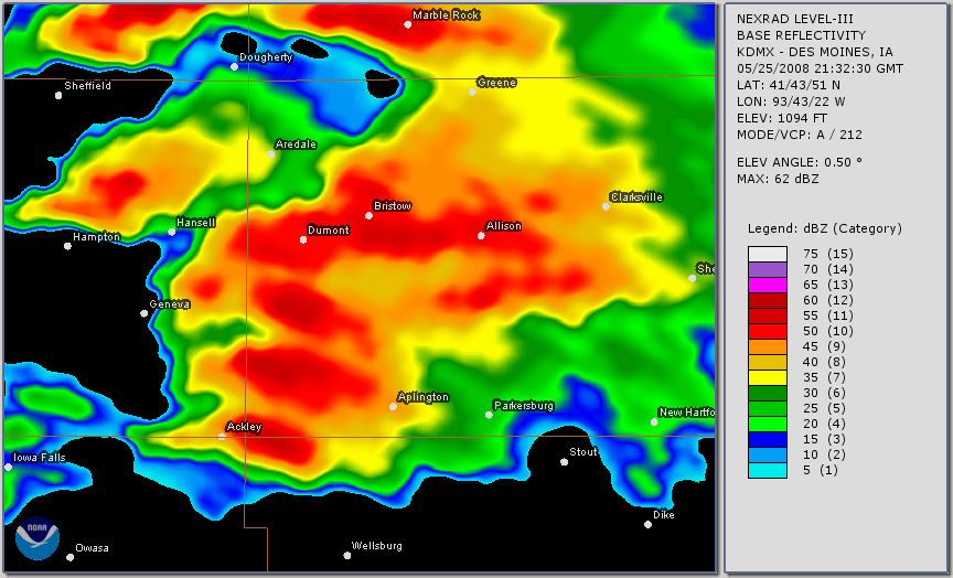
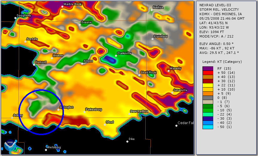
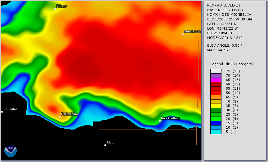
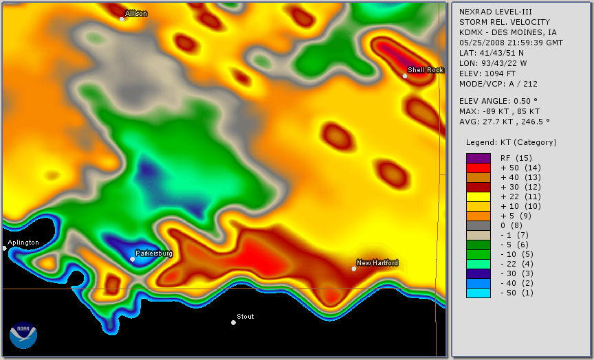
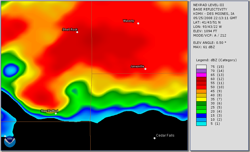
The radar above showed the storm moving into southern Butler and northern Grundy Counties. The small red area east of Ackley was to be where the tornado would come out from. At 4:46pm, the NWS in Des Moines reissued the tornado warning specifically to Butler and Northern Grundy Counties
View Text
BULLETIN – EAS ACTIVATION REQUESTED
TORNADO WARNING
NATIONAL WEATHER SERVICE DES MOINES IA
446 PM CDT SUN MAY 25 2008
THE NATIONAL WEATHER SERVICE IN DES MOINES HAS ISSUED A

* TORNADO WARNING FOR…
NORTHERN GRUNDY COUNTY IN CENTRAL IOWA…
SOUTHEASTERN BUTLER COUNTY IN NORTH CENTRAL IOWA…

* UNTIL 530 PM CDT.

* AT 441 PM CDT…NATIONAL WEATHER SERVICE DOPPLER RADAR INDICATED A
SEVERE THUNDERSTORM CAPABLE OF PRODUCING A TORNADO 7 MILES
SOUTHWEST OF APLINGTON…OR 33 MILES WEST OF WATERLOO…MOVING
NORTHEAST AT 36 MPH.

* THE TORNADO WILL BE NEAR…
APLINGTON BY 455 PM CDT…
PARKERSBURG BY 500 PM CDT…
ALLISON BY 510 PM CDT…
SHELL ROCK AND CLARKSVILLE BY 520 PM CDT…

THIS IS A HAZARDOUS SITUATION. SEEK SHELTER IN A BASEMENT…OR IN AN
INTERIOR ROOM. STAY AWAY FROM WINDOWS. IF YOU ARE OUTSIDE OR IN A
CAR…SEEK SHELTER IN A REINFORCED BUILDING.

A TORNADO WATCH REMAINS IN EFFECT UNTIL 900 PM CDT SUNDAY EVENING FOR
NORTHWESTERN IOWA.
Two minutes later the tornado dropped two miles south of Aplington moving to the east. The NWS issued a statement 3 minutes after touchdown,
View Text
IAC023-075-252230-
/O.CON.KDMX.TO.W.0013.000000T0000Z-080525T2230Z/
BUTLER IA-GRUNDY IA-
451 PM CDT SUN MAY 25 2008
…A TORNADO WARNING REMAINS IN EFFECT UNTIL 530 PM CDT FOR NORTHERN
GRUNDY AND SOUTHERN BUTLER COUNTIES…

AT 450 PM CDT…TRAINED WEATHER SPOTTERS REPORTED A TORNADO. THIS
TORNADO WAS LOCATED NEAR APLINGTON…OR 30 MILES WEST OF WATERLOO…
MOVING NORTHEAST AT 33 MPH.

THE TORNADO WILL BE NEAR…
PARKERSBURG BY 500 PM CDT…
8 MILES NORTHWEST OF STOUT BY 505 PM CDT…
8 MILES SOUTHEAST OF ALLISON AND 8 MILES NORTHWEST OF NEW HARTFORD
BY 515 PM CDT…
SHELL ROCK AND 6 MILES SOUTHEAST OF CLARKSVILLE BY 525 PM CDT…

AT 448 PM…SPOTTERS REPORTED A CONFIRMED TORNADO AT THE
INTERSECTION OF COUNTY ROAD T19 AND HIGHWAY 57 IN BUTLER
COUNTY…HEADING TOWARD APPLINGTON.
At 4:58 as the tornado neared the south side of Parkersburg, the NWS issued a statement once more
View Text
IAC023-075-252230-
/O.CON.KDMX.TO.W.0013.000000T0000Z-080525T2230Z/
BUTLER IA-GRUNDY IA-
458 PM CDT SUN MAY 25 2008

…A TORNADO WARNING REMAINS IN EFFECT UNTIL 530 PM CDT FOR NORTHERN
GRUNDY AND SOUTHERN BUTLER COUNTIES…

AT 455 PM CDT…TRAINED WEATHER SPOTTERS REPORTED A TORNADO. THIS
TORNADO WAS LOCATED NEAR PARKERSBURG…OR 25 MILES WEST OF
WATERLOO…MOVING NORTHEAST AT 40 MPH.

THE TORNADO WILL BE NEAR…
NEW HARTFORD BY 510 PM CDT…
SHELL ROCK AND 9 MILES SOUTHEAST OF CLARKSVILLE BY 515 PM CDT…

AT 452…A SPOTTER REPORTED A LARGE TORNADO NEAR THE INTERSECTION OF
HIGHWAY D17 AND HIGHWAY 14.

MULTIPLE TORNADOES ARE FORMING EAST OF APLINGTON.

THIS IS AN EXTREMELY DANGEROUS AND LIFE THREATENING SITUATION. THIS
STORM IS CAPABLE OF PRODUCING STRONG TO VIOLENT TORNADOES. IF YOU ARE
IN THE PATH OF THIS TORNADO…TAKE COVER IMMEDIATELY!
A minute later (4:59pm) the tornado swept through the south side of Parkersburg.
The NWS issued a new warning for Black Hawk and Bremer County at 5:04pm
View Text
BULLETIN – EAS ACTIVATION REQUESTED
TORNADO WARNING
NATIONAL WEATHER SERVICE DES MOINES IA
504 PM CDT SUN MAY 25 2008
THE NATIONAL WEATHER SERVICE IN DES MOINES HAS ISSUED A

* TORNADO WARNING FOR…
NORTHERN BLACK HAWK COUNTY IN NORTHEAST IOWA…
BREMER COUNTY IN NORTHEAST IOWA…

* UNTIL 600 PM CDT.

* AT 459 PM CDT…NATIONAL WEATHER SERVICE DOPPLER RADAR WAS TRACKING
A TORNADO 13 MILES WEST OF JANESVILLE…OR 19 MILES WEST OF
WATERLOO…MOVING NORTHEAST AT 33 MPH.

* THE TORNADO WILL BE NEAR…
JANESVILLE BY 520 PM CDT…
WAVERLY BY 525 PM CDT…
DENVER BY 535 PM CDT…
READLYN AND TRIPOLI BY 545 PM CDT…
ORAN BY 555 PM CDT…
SUMNER BY 600 PM CDT…

THIS THUNDERSTROM HAS A HISTORY OF PRODUCING LARGE TORNADOES IN THE
APLINGTON AREA. A LARGE TORNADO HAS BEEN REPORTED EAST OF APLINGTON.

THIS IS A HAZARDOUS SITUATION. SEEK SHELTER IN A BASEMENT…OR IN AN
INTERIOR ROOM. STAY AWAY FROM WINDOWS. IF YOU ARE OUTSIDE OR IN A
CAR…SEEK SHELTER IN A REINFORCED BUILDING.

A TORNADO WATCH REMAINS IN EFFECT UNTIL 1000 PM CDT SUNDAY EVENING
FOR IOWA. A TORNADO WATCH ALSO REMAINS IN EFFECT UNTIL 900 PM CDT
SUNDAY EVENING FOR NORTHWESTERN IOWA.
The tornado continued slightly north of east heading toward New Hartford hitting a subdivision just north of the town around 5:10pm.
The tornado moved into Black Hawk County around 5:20pm and just missed the north end of Cedar Falls and Waterloo by less than a mile as it went through the countryside of northern Black Hawk County.
View Text
IAC013-017-252245-
/O.CON.KDMX.TO.W.0015.000000T0000Z-080525T2245Z/
BREMER IA-BLACK HAWK IA-
531 PM CDT SUN MAY 25 2008
…A TORNADO WARNING REMAINS IN EFFECT UNTIL 545 PM CDT FOR BLACK
HAWK AND SOUTHERN BREMER COUNTIES…

AT 526 PM CDT…NATIONAL WEATHER SERVICE DOPPLER RADAR AND STORM
SPOTTERS WERE TRACKING A LARGE AND EXTREMELY DANGEROUS TORNADO. THIS
TORNADO WAS LOCATED NEAR CEDAR FALLS…OR 7 MILES NORTHWEST OF
WATERLOO…MOVING EAST AT 33 MPH.

THE TORNADO WILL BE NEAR…
EVANSDALE BY 540 PM CDT…
ELK RUN HEIGHTS…RAYMOND…6 MILES SOUTHWEST OF DUNKERTON AND 8
MILES NORTH OF GILBERTVILLE BY 545 PM CDT…

THIS IS AN EXTREMELY DANGEROUS AND LIFE THREATENING SITUATION. THIS
STORM IS CAPABLE OF PRODUCING STRONG TO VIOLENT TORNADOES. IF YOU ARE
IN THE PATH OF THIS TORNADO…TAKE COVER IMMEDIATELY!

AT 528 PM…SPOTTERS REPORTED A LARGE TORNADO AT THE INTERSECTION OF
557 AND HIGHWAY 218 IN BLACKHAWK COUNTY. THE TORNADO IS NOW IN THE
NORTHEAST SIDE OF CEDAR FALLS AND HEADED TO NORTH SIDE OF WATERLOO.
The tornado significantly widened at this point to well over a mile producing EF2 and greater damage as it neared the town of Dunkerton. 3 miles west of Dunkerton, the tornado turned more northeast and missed the town by 2 miles to the north as it then headed toward Fairbank. The tornado lifted just before it was to enter into Buchanan County, but the storm was far from over.
The damage was done to the town of Parkersburg and the subdivision just north of New Hartford. Several other residents and farms between the two towns and on eastward into Black Hawk County were also damaged if not destroyed. The storm however wasn’t done producing tornadoes. As everyone begin to assess the situation in those communities that evening, the tornadic storm was not done producing tornadoes as it moved across Buchanan, Delaware and Dubuque counties.
15 minutes after the Parkersburg-New Hartford tornado had lifted between Dunkerton and Fairbank, Tornado #2 formed from the same thunderstorm. Rated an EF3 Tornado. This one would be on the ground for over an hour (6:05pm-7:10pm) with a damage path of over 32 miles. This storm would injure 3 people. Several mobile homes at a dealership in Hazleton were destroyed by the tornado, with several more residents receiving damage. As this tornado was moving through another tornado formed briefly south of Lamont around 6:40pm with some damage along its two mile path.
The next tornado formed southwest of Petersburg (from the same thunderstorm once again) 20 minutes after the second tornado lifted. This would be on the ground for just under 8 miles with it being rated an EF1. This tornado did damage to some out buildings and numerous trees. The tornadic storm continued into Dubuque County and even into Jo Daviess County IL after 9pm before the circulation weakened enough. Two other tornadoes dropped in eastern Iowa later that night as part of a complex of thunderstorms that then raced across the state. Along with another tornado (mainly forgotten in southern Iowa around the same time as the Parkersburg storm). The tornado would kill 9 people, the most fatalities in a tornado in the state since the 1968 Charles City Tornado (also an EF5/F5 Tornado)
NWS Des Moines’ Report on the Parkersburg-New Hartford Tornado
NWS Quad Cities Damage Surveys From May 25th 2008
Parkersburg Tornado Service Assessment
KCRG’s Coverage of Parkersburg Tornado
House Getting Destroyed in Parkersburg Tornado
