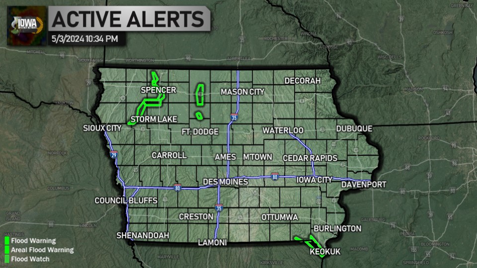

FLOOD WARNING
(5 counties)Appanoose, Lucas, Monroe, Wapello, Wayne
Until 7:00 AM Friday
WHAT...Flooding caused by excessive rainfall is expected. WHERE...Portions of south central and southeast Iowa, including the following counties, in south central Iowa, Appanoose, Lucas, Monroe and Wayne. In southeast Iowa, Wapello. WHEN...Until 700 AM CDT Friday. IMPACTS...Flooding of rivers, creeks, streams, and other low-lying and flood-prone locations is imminent or occurring. ADDITIONAL DETAILS... - At 730 PM CDT, Emergency management reported continued road closures for at least 10 roadways that are expected to remain through the night. Old Highway 34 East of Albia continues to have up to 2 feet of standing water in spots. Water is slow to recede due to debris in the riverbanks. - Emergency management reported that 6 inches of rain had fallen north of Blakesburg. Additional rainfall amounts up to 0.5 inches are possible in the warned area. - Some locations that will experience flooding include... Chariton, Albia, Corydon, Eddyville, Rathbun Lake, Ottumwa Industrial Airport, Seymour, Moravia, Russell, Lovilia, Allerton, Humeston, Mystic, Blakesburg, Lineville, Kirkville, Derby, Melrose, Promise City and Chillicothe. - http://www.weather.gov/safety/flood
Turn around, don't drown when encountering flooded roads. Most flood deaths occur in vehicles. For the latest river and stream observations and forecasts on the Internet refer to https://water.noaa.gov.
Until 7:00 AM Friday
More Information
Turn around, don't drown when encountering flooded roads. Most flood deaths occur in vehicles. For the latest river and stream observations and forecasts on the Internet refer to https://water.noaa.gov.
SPECIAL WEATHER STATEMENT
(38 counties)Adair, Adams, Audubon, Black Hawk, Boone, Bremer, Butler, Carroll, Cass, Cerro Gordo, Clarke, Crawford, Dallas, Franklin, Greene, Grundy, Guthrie, Hamilton, Hancock, Hardin, Jasper, Lucas, Madison, Mahaska, Marion, Marshall, Monroe, Polk, Poweshiek, Story, Tama, Taylor, Union, Warren, Webster, Winnebago, Worth, Wright
Until 7:45 AM Friday
Until 7:45 AM Friday
More Information
Fog is developing over the region. River valleys and low lying areas are seeing the thickest fog at this time. Over the next several hours, fog is expected to become more widespread. Visibility will range from a few miles and quickly change to 1/4 mile or less. If traveling early today through the morning commute, use caution. Allow extra time to reach your destination safely; use low beam headlights and be extra cautious at intersections and railroad crossings if visibility is low. The fog should begin lifting and conditions improving after 7 to 8 am this morning.