ABOUT SKYWARN
ABOUT SKYWARN
Real-time reports are critical in issuing warnings and saving lives. That’s an indisputable fact. Spotters are provide this real-time ground-truth of local conditions - such as hail size, wind speed, tornado development, and local damage - to help warn the public. Even as new technology allows the National Weather Service to issue warnings with greater lead time, spotters will always serve as a critical link between radar indications of severe weather and what’s happening on the ground.
Who are spotters? Virtually every community has some form of spotter network. Often, local fire and police personnel are trained to observe and report severe weather, partly due to their extensive radio communication and 24-hour operations. Citizens may also be an active part of the spotter network, some with an avid interest in the weather and many without. Some spotters are amateur radio operators. All share a sense of responsibility to their neighbors.
What is SKYWARN? SKYWARN is a program sponsored by the National Weather Service. The program is made up of thousands of volunteers who attend regular training and then scan the skies of their communities identifying and reporting critical storm information. These volunteers, sometimes organized under the SKYWARN banner in the U.S., are typically trained by NWS forecasters to be the eyes and ears of both the warning forecasters and the local public safety networks.

HOW TO REPORT
For a list of which counties in each office and more information on how to report:
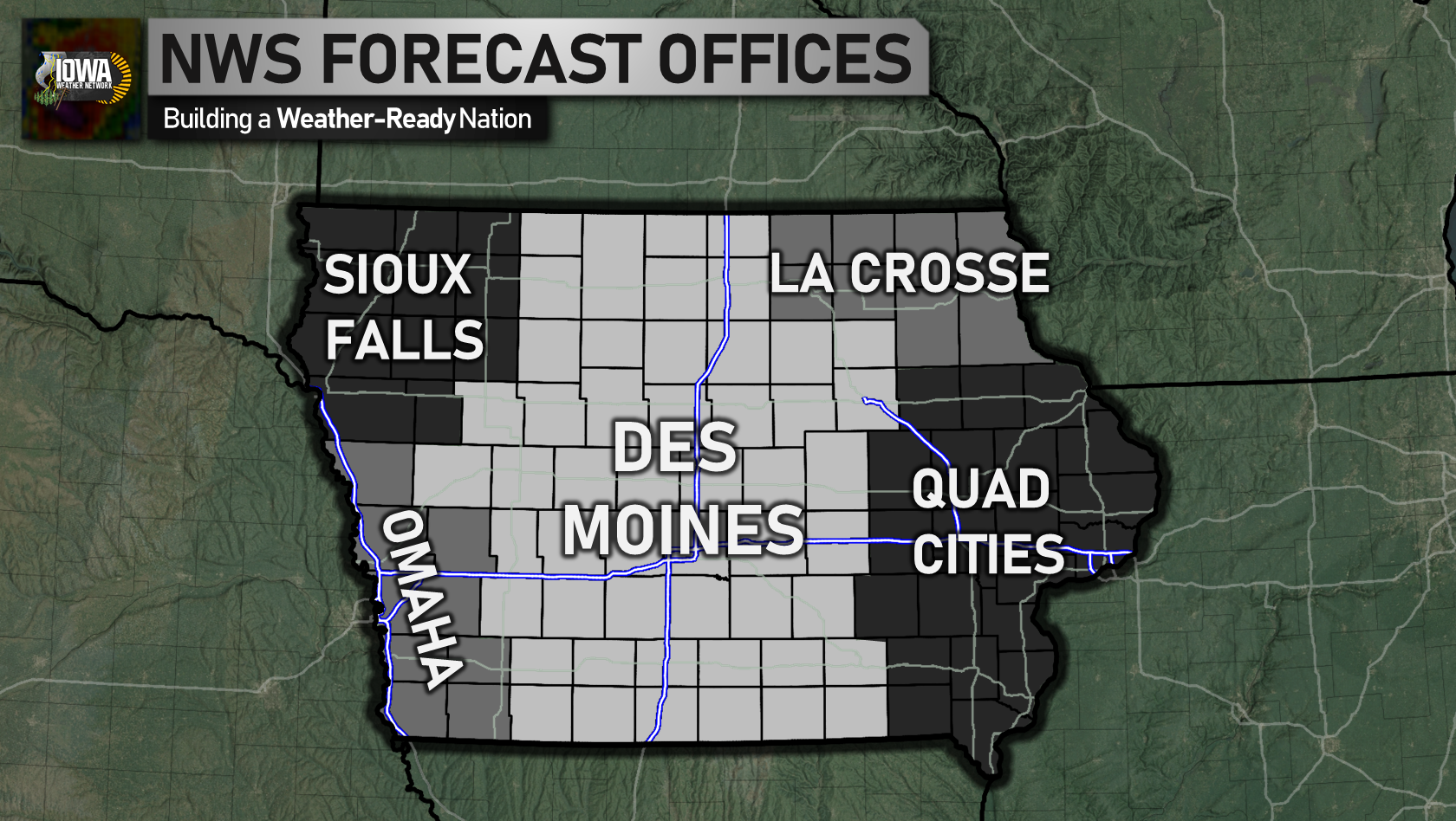
National Weather Service Des Moines, Iowa
Adair, Adams, Appanoose, Audubon, Black Hawk, Boone, Bremer, Butler, Calhoun, Carroll, Cerro Gordo, Clarke, Crawford, Dallas, Davis, Decatur, Emmet, Franklin, Greene, Grundy, Guthrie, Hamilton, Hancock, Hardin, Humboldt, Jasper, Kossuth, Lucas, Madison, Mahaska, Marion, Marshall, Monroe, Palo Alto, Pocahontas, Polk, Poweshiek, Ringgold, Sac, Story, Tama, Taylor, Union, Wapello, Warren, Wayne, Webster, Winnebago, Worth, Wright- TORNADOES: 1-800-SKYWARN
- Online
- Email: [email protected]
- Text Message: (515) 240-5515
- Telephone: 1 (800) SKYWARN
- Twitter: @NWSDesMoines.
- mPing
- Amateur Radio: KØDMX.
National Weather Service Quad Cities, Iowa/Illinois
Benton, Buchanan, Cedar, Clinton, Delaware, Des Moines, Dubuque, Henry, Iowa, Jackson, Jefferson, Johnson, Jones, Keokuk, Lee, Linn, Louisa, Muscatine, Scott, Van Buren, Washington- TORNADOES: 1-800-SKYWARN
- Telephone: 1 (800) SKYWARN
- Twitter: @NWSQuadCities.
- mPing
National Weather Service Sioux Falls, South Dakota
Buena Vista, Cherokee, Clay, Dickinson, Ida, Lyon, O'Brien, Osceola, Plymouth, Sioux, Woodbury- TORNADOES: 1-800-SKYWARN
- Online
- Email: [email protected]
- Telephone: 1 (800) SKYWARN
- Twitter: @NWSSiouxFalls.
- mPing
National Weather Service La Crosse, Wisconsin
Allamakee, Chickasaw, Clayton, Fayette, Floyd, Howard, Mitchell, Winneshiek- TORNADOES: 1-800-SKYWARN
- Online
- Email: [email protected]
- Telephone: 1 (800) SKYWARN
- Twitter: @NWSLaCrosse.
- mPing
National Weather Service Omaha/Valley, Nebraska
Cass, Fremont, Harrison, Mills, Monona, Montgomery, Page, Pottawattamie, Shelby- TORNADOES: 1-800-SKYWARN
- Online
- Email: [email protected]
- Telephone: 1 (800) SKYWARN
- Twitter: @NWSOmaha.
- mPing
WHAT TO REPORT
TORNADOES
Distance and direction from your location
Movement (tornado direction and speed)
Impacts: damage, injuries, fatalities
Tornado Behavior: growing larger? Roping out?
FUNNEL/WALL CLOUDS
FUNNEL/WALL CLOUDS
Wall cloud: Rotating? Persistent?
Funnel Cloud: How far to the ground Visible rotation with the funnel?
Dust or debris below the funnel? (if so, you have a tornado!)
LARGE HAIL
Diameter of the largest hailstone (estimated or measured)
DO NOT report marble-sized hail! Marbles vary widely in size.
Damage to windows, cars, crops, etc.
DAMAGING WIND
DAMAGING WIND
Wind speed (estimated or measured)
Damage to trees, power lines, and structures
Trees: Diameter of limbs snapped off and health of tree (old or rotten?)
FLOODING
Flood Impacts: Roads, houses, etc.
Depth of the water
Is the water moving swiftly or slowly?
Damage: Roads washed out, etc.
Rainfall amounts & how quickly it fell
SNOW
Amount: (measured or estimated) Take multiple measurements and average them if possible.
Damage or impacts such as downed power lines, snapped tree limbs, cars off the road, etc.
SPOTTER TRAINING
NWS La Crosse, who covers the northeastern part of the state, unfortunately doesn't offer a Google Calendar to view their spotter dates. Spotter training dates for those in Allamakee, Chickasaw, Clayton, Fayette, Floyd, Howard, Mitchell, and Winneshiek counties can visit this page for information regarding training dates.
AMATEUR RADIO
Weather Radio Frequencies
| 162.400 MHz | 162.425 MHz | 162.450 MHz | 162.475 MHz | 162.500 MHz | 162.525 MHz |
Common Frequencies
| Frequency | Description |
|---|---|
| 146.550 MHz | Simplex frequency commonly used or monitored by chasers |
| 146.460 MHz | Alternate to 146.55 MHz |
| 223.520 MHz | Simplex 1.25 Meters |
| 446.075 MHz | Simplex Often used for cross-patching to 146.550 (70cm) |
| 446.100 MHz | Alternate to 446.075 |
| 1294.550 MHz | Simplex 23 cm |
Amateur Radio Frequencies
| Location | Primary Freq | Primary PL | Secondary Freq | Secondary PL |
|---|---|---|---|---|
| Afton | 442.400+ | 151.4 | ||
| Anamosa | 145.390 | 77.0 | ||
| Baxter | 442.225+ | 151.4 | ||
| Bedford | 147.135+ | 203.5 | ||
| Burlington | 146.790 | |||
| Cedar Rapids | 146.745 | 192.8 | 145.150 | 192.8 |
| Clinton | 145.430 | 100.0 | ||
| Coralville | 444.750+ | 151.4 | ||
| Cresco | 146.925- | 103.5 | ||
| Creston | 146.790+ | 136.5 | ||
| Decorah | 146.670- | 103.5 | 147.165+ | 123.0 |
| Des Moines | 146.820- | 203.5 | ||
| Dubuque | 147.240 | 114.8 | ||
| Fort Madison | 146.865 | 100 | ||
| Greenfield | 444.500+ | 173.8 | ||
| Grimes | 146.610- | 114.8 | 443.400+ | 151.4 |
| Iowa City | 146.850 | 192.8 | 145.270 | 192.8 |
| Lenox | 146.880- | 136.5 | ||
| Mason City | 146.760- | 103.5 | 147.315+ | 203.5 |
| Menlo | 147.045+ | 114.8 | ||
| Mount Pleasant | 147.390 | 100.0 | ||
| Muscatine | 145.370 | 100 | 145.370 | 100 |
| Newton | 442.300+ | 151.4 | ||
| Osceola | 147.210+ | 114.8 | ||
| Pella | 145.170- | 203.5 | ||
| Quad Cities | 146.880 | 77.0 | 146.700 | |
| Scranton | 444.300+ | 151.4 | ||
| St. Ansgar | 147.195+ | 103.5 | ||
| Washington | 147.045 | 443.000 | 100 | |
| Williams | 444.500+ | 151.4 |
MURS
Multi-Use Radio Service- Unlicensed
- Transmitter Power Output limited to 2 Watts
- Repeaters Not Allowed
| Frequency | Bandwidth |
|---|---|
| 151.820 MHz | 11.25 KHz |
| 151.880 MHz | 11.25 KHz |
| 151.940 MHz | 11.25 KHz |
| 154.570 MHz | 20.00 KHz |
| 154.600 MHz | 20.00 KHz |
FRS
Family Radio Service- Unlicensed
- Restricted to 0.5 Watts
- Repeaters Not Allowed
| Chan | Freq | Shared? | |
|---|---|---|---|
| 1 | 462.5625 MHz | Yes* | |
| 2 | 462.5875 MHz | Yes* | |
| 3 | 462.6125 MHz | Yes* | |
| 4 | 462.6375 MHz | Yes* | |
| 5 | 462.6625 MHz | Yes* | |
| 6 | 462.6875 MHz | Yes* | |
| 7 | 462.7125 MHz | Yes* | |
| 8 | 467.5625 MHz | No | |
| 9 | 467.5875 MHz | No | |
| 10 | 467.6125 MHz | No | |
| 11 | 467.6375 MHz | No | |
| 12 | 467.6625 MHz | No | |
| 13 | 467.6875 MHz | No | |
| 14 | 467.7125 MHz | No |
*License required on the frequency if using more than the 0.5 Watts, up to the 5 Watt Maximum
GMRS
General Mobile Radio Service- FCC License Required
- Allowed to 50 Watts, Except on FRS/GMRS Shared
- Repeaters Allowed (Upper Frequency is for Repeater Inputs, Lower for Output/Simplex)
- Use of 650 and 700 channel pairs is prohibited near Canadian border. See FCC website for details.
- 675 channel is suggested nationwide emergency and road information calling. Nationally recognized coded squelch for 675 emergency repeater operation is 141.3 Hz.
| Chan | Low Freq | High Freq |
|---|---|---|
| 550 | 462.550 MHz | 467.550 MHz |
| 575 | 462.575 MHz | 467.575 MHz |
| 600 | 462.600 MHz | 467.600 MHz |
| 625 | 462.625 MHz | 467.625 MHz |
| 650 | 462.650 MHz | 467.650 MHz |
| 675 | 462.675 MHz | 467.675 MHz |
| 700 | 462.700 MHz | 467.700 MHz |
| 725 | 462.725 MHz | 467.725 MHz |
SPOTTER RESOURCES
- Cloud Chart
- Role of the Spotter Course (MetEd)
- Spotter Course (MetEd)
- Spotter Do's and Don'ts (NWS Des Moines)
- Spotter Field Guide
- Storm Spotter Reference Sheet (NWS Des Moines)
- Storm Spotter Reference Sheet (NWS Quad Cities)
EF Scale
| Category | Wind | Damage |
|---|---|---|
| EF-0 | 65-85 MPH | Light |
| EF-1 | 86-109 MPH | Moderate |
| EF-2 | 110-137 MPH | Considerable |
| EF-3 | 138-167 MPH | Severe |
| EF-4 | 168-199 MPH | Devastating |
| EF-5 | 200+ MPH | Incredible |
Beaufort Scale
| Wind Speed | Description |
|---|---|
| 1-3 MPH | Wind motion visible in smoke |
| 3-7 MPH | Wind smoke felt on exposed skin, leaves rustle |
| 8-12 MPH | Leaves and small twigs in constant motion |
| 13-17 MPH | Dust and loose paper raised, small branches move |
| 18-24 MPH | Branches of a moderate size move, small trees begin to sway |
| 25-30 MPH | Large branches in motion. Whistling heard in overhead wires. Umbrella use becomes difficult. Empty plastic garbage cans tip over. |
| 31-38 MPH | Whole trees in motion. Effort needed to walk against the wind. Swaying of skyscrapers may be felt, especially by people on upper floors. |
| 39-46 MPH | Twigs broken from trees. Cars veer on road. |
| 47-54 MPH | Larger branches break off trees, and some small trees blow over. Construction/temporary signs and barricades blow over. Damage to circus tents and canopies. |
| 55-63 MPH | Trees are broken off or uprooted, saplings bent and deformed, poorly attached asphalt shingles and shingles in poor condition peel off roofs. |
| 64-72 MPH | Widespread vegetation damage. More damage to most roofing surfaces, asphalt tiles that have curled up and/or fractured due to age may break away completely. |
| >73 MPH | Considerable and widespread damage to vegetation, a few windows broken, structural damage to mobile homes and poorly constructed sheds and barns. Debris may be hurled about. |
Hail Size Chart
| Size | Description |
|---|---|
| 0.25" | Pea |
| 0.50" | Plain M&M |
| 0.75" | Penny |
| 0.88" | Nickel |
| 1.00" | Quarter |
| 1.25" | Half Dollar |
| 1.50" | Ping Pong Ball |
| 1.75" | Golf Ball |
| 2.00" | Lime |
| 2.50" | Tennis Ball |
| 2.75" | Baseball |
| 3.00" | Teacup |
| 4.00" | Grapefruit |
| 4.50" | Softball |
| 5.00" | CD/DVD |